Morning update: storm warning downgraded to Winter Weather Advisory for metro area.
So, we know now that the old ‘wintry mix’ won out and kids of all ages lost out on a day to play in the snow!
Even though most kids are out of school, the issues today will now center around areas of sleet (bits of ice falling) and freezing rain (liquid drops falling that hit a frozen sign or sidewalk and turn to ice) and plain old vanilla cold rain.
Remember yesterday when I talked about a gradual warm up happening above us that would put an end to the snow? Well, it happened quickly this morning and dashed the hopes for a snowy snow day!
So far, most major roads in the I-5 Corridor are in pretty good shape and except in areas that drop to about 30 degrees (this would be isolated) the main roads should stay wet.
Winter Storm Warnings continue for the Gorge and Cascades for snow and potentially areas of freezing rain.
That’s the update—I hope you have a great day!
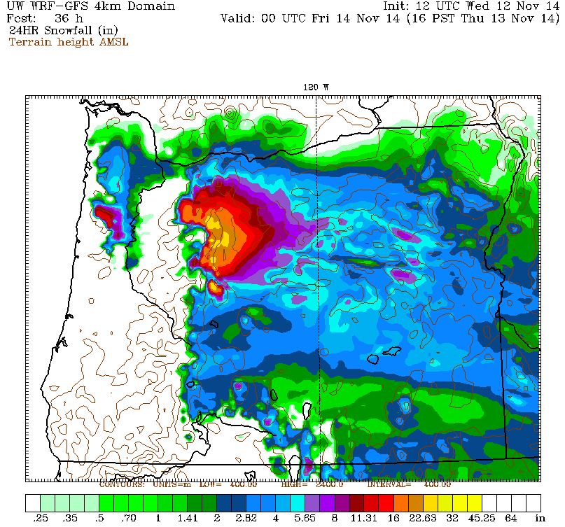
See the picture on this blog post?Â
It shows the amount of snow expected to fall over Oregon and Washington by 4pm Thursday.Â
It’s clear the biggest bullseye is painted over the Cascades and the Columbia River Gorge.
But if this particular model forecast is right, even Portland will be measuring the snow in inches on Thursday!
(10:53pm update – forecast is on track except a little later start. Some sort of wintry mix to PDX between 6-8am, then likely becoming all snow by 9am-ish.)
Below is the forecast I wrote today for my Bruce Sussman Weather App–available for Android and Apple. The forecast still holds and I will update it on my app mid-late evening tonight after the latest ‘model runs’ are in.
I’ve looked at four different forecast models this morning…these models basically paint a picture of what is likely to happen. So here is the latest:
For starters, it looks like lots of us in the I-5 Corridor will get to at least see snow early Thursday. Perhaps as far south as Salem.
Next, three out of four forecast models say most of the Portland-Vancouver metro area will see accumulating snow Thursday morning,
starting sometime in a window from about 5am – 7am depending on how quickly the system moves in.
The WRF-GFS and the Euro model both give 2-3†or so for the heart of the Portland area with amounts decreasing quickly as you go north of about Vancouver and south of about Wilsonville.
The models also give significantly higher amounts toward Banks and Forest Grove where cold air blowing out of the Gorge hits the Coast Range and pools up. Deeper cold air means snow can last longer. Models give those of you there 3-6†of snow.
This will be a very wet, sloppy and heavy snow. It’s the most slippery kind of snow to drive in if it accumulates and it’s the most likely to cause power outages because it weighs down branches and power lines.
Worth noting, however, is that the RPM model which I used during my time on local TV gives us nothing except a cold rain. Won’t it be interesting if it outdoes the others? We’ll find out soon enough but for now I have to play the percentages and go with the other models!
So if we start with or transition to at least some snow…the million dollar question is how long does it last? I really do not have a good answer to that right now because the air above us should gradually warm as we go through the day. As it does, some areas transition to sleet or freezing rain then plain old rain.
This probably happens by sunrise or thereabouts for places like Salem, then the transition line moves north as the day goes on. So the best way to start in the morning is see what is happening before you set out as usual on your day.
Two other things I want to mention. For one thing, if our air temperature is above freezing (it will be a close call) some areas will go from snow to regular old rain very quickly. That means we wash away any snow that has accumulated as we do so often around here. But again, this could take awhile to make the transition around Portland–some of the models say that will wait until sometime in the afternoon!
The second thing is this: I would absolutely not drive over the Cascades or through the Gorge tomorrow. Put off your trip by a day. A Blizzard Warning is in place for the Gorge and some areas may get close to a foot of snow by evening in addition to areas of freezing rain. The Cascades and Mt. Hood could see up to two feet of snow from this storm. Gotta love the instant winter on the mountain, right? Especially if you have a season pass!
Central Oregon will also see snow totals of 2-8†by Thursday night. So even though it’s fall, this truly is a ‘winter’ storm!
thanks Bruce, I love hearing all the different scenarios and your interpretation of what you think may happen and why.I’ll act like I know what I’m talking about talking to people about the weather now! Thanks buddy talk to you later,
Craig
As usual the most comprehensive and understandable of all the weather reports I’ve seen today. No one else talks about how long the roads will be impassable. I don’t have to be anywhere until about noon and it sounds like we may just have plain old rain by then. Thanks Bruce!
Bruce
You are really missed.
Pretty faces don’t cut it.
I go back to Jack Capel times and you are in that category.
Do you have plans of being back on a real station?
I hope so, because we have a big void now.
Thanks
Bob
Bob:
Thanks so much for the compliment: I learned so much from my days of working with Jack!
I’m doing some occasional weather in Seattle right now and working on a bunch of other projects. No definite plans yet…
Have a great weekend,
Bruce
Thanks for taking the time to give us such a thorough assessment of the weather & forecast, Bruce! Don, my husband, likes that I found your app also ( so that I can inform him !) .
Diana:
I love that you guys like and use my app. Thank you!
Tell Don hi and thanks for stopping by the blog.
Bruce