 9:30pm Update: except along the coast and a few places northwest of Portland, the storm under-delivered in the snow department. In western Washington, especially north of Clark County, it snowed for hours many places.
We may have an hour or two of snow overnight for most of the Portland area, however, given our temperatures, it will melt quite a bit. It is hard to see any Monday morning problems for most of us, based on what I’m seeing now.Â
Thanks for tracking the weather here this weekend – and wow, what a Super Bowl!
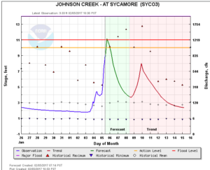
The chart to the right shows Johnson Creek rising fast and forecast to get close to flood stage, which is the red line.
Pineapple Express
Watch your backyard streams and creeks as most of us continue to be pummeled by the pineapple express for at least the next few hours. For some of us it will continue into early tomorrow morning and the rain totals will be measured in inches.
Polar Express
Many of us are in for a change to snow, mainly this afternoon or tonight. But some of us will be too far south and stay rain. The way this storm is lined up, there will be a pretty sharp diving line between the “have inches of snow” and “only have pouring rain” – I’m just not sure where in the Willamette Valley that line will be. It could even be in the metro area.
I live at 530′ and we’re having occasional snowflakes mix into the pouring rain, since about 9am Sunday. And the temperature trend at Portland Airport is going the right way, along with falling dew points which indicates there is more “cooling potential” in the air–that is absolutely key.Â
PDX Temperatures Trend – Sunday February 5 – headed in the direction of snow:
- 41 degrees – 8am
- 40 degrees – 9am
- 37 degrees – 10am
- 36 degrees – 10:30amÂ
Meanwhile, in this same timeframe, Salem has been bouncing back between 42 and 43 degrees. This suggests that for those of you in the central valley, if you do switch to snow, it’s going to be much later and amounts would be less.
Grading On A Bellcurve
Remember those teachers in high school who always graded on a curve, where a certain percentage of people had As, etc? This setup is going to be kind of like that. A few of us will get a major snowstorm out of this, potentially seeing 6″ or more, others will be in the middle of the bellcurve and may get an inch or two up to a few inches and some of us will be getting the equivalent of an F — and flunk out of the snow accumulation scores altogether!
For much or most of the Portland Vancouver metro area I still believe some accumulating snow is possible, with highest amounts north and in the hilly parts of town – even a few hundred feet in elevation will help in this case. The majority of accumulation could be tonight and overnight.
What to expect on Monday
Snow amounts will speak for themselves.  By 5am tomorrow the steady rain and snow should have moved out with a mix of snow and rain showers around Monday but additional accumulation is unlikely. Temperatures will range from 31-38 depending on whether you had snow on the ground to cool your air. If not, it’s likely just another damp and cool northwest morning at your house where roads are wet.Â
Let me know what happens at your place!
Leave a Reply