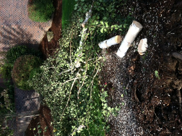
 This is the sad truth: one of the Sussman family trees did not survive the weekend wind storm.
But at least we kept the lights on the whole time.
 We are thankful for that.
For at least 75,000 customers in Oregon and nearly 100,000 customers in Western Washington (including the Seattle area) the lights went out.
The storm was well forecast several days in advance and it followed a type of ‘classic’ wind storm track. Many of you have asked about the peak gusts where you were during the storm. Well, here are the comprehensive lists from the National Weather Service office in Portland (top) and the National Weather Service Office In Seattle (scroll down). These are long and a pretty crazy read!
PUBLIC INFORMATION STATEMENT
 NOUS46 KPQR 260345 AAA
 PNSPQR

 PUBLIC INFORMATION STATEMENT...UPDATED
 NATIONAL WEATHER SERVICE PORTLAND OR
 845 PM PDT SAT OCT 25 2014

 UPDATED TO INCLUDE ADDITIONAL WIND GUST REPORTS.
 ...LATEST WIND REPORTS FROM THE PAST 12 HOURS AS OF 745 PM PDT...

 LOCATION                       SPEED     TIME/DATE       LAT/LON

 ...OREGON...

 ...BENTON...
 MARYS PEAK                     91 MPH    0150 PM 10/25   44.50N/123.55W
 CORVALLIS MUNICIPAL AIRPORT    45 MPH    0215 PM 10/25   44.50N/123.29W
 CORVALLIS                      43 MPH    1200 PM 10/25   44.63N/123.19W

 ...CLACKAMAS...
 2 SSW MOUNT HOOD               94 MPH    0600 PM 10/25   45.35N/121.71W
 WANDERERS PEAK                 58 MPH    0307 PM 10/25   45.11N/122.20W
 CLACKAMAS                      48 MPH    0530 PM 10/25   TRAINED SPOTTER
 CANBY                          48 MPH    0335 PM 10/25   TRAINED SPOTTER
 2 ENE HAPPY VALLEY             47 MPH    0140 PM 10/25   45.46N/122.50W
 6 SSE MOLALLA                  46 MPH    0321 PM 10/25   45.07N/122.54W
 4 SSW ESTACADA                 44 MPH    0510 PM 10/25   45.23N/122.35W
 EAGLE CREEK                    41 MPH    0613 PM 10/25   45.37N/122.33W
 2 SSE WILSONVILLE              41 MPH    0330 PM 10/25   45.28N/122.75W

 ...CLATSOP...
 1 SW SEASIDE                   59 MPH    0120 PM 10/25   45.98N/123.93W
 CLATSOP SPIT                   59 MPH    0130 PM 10/25   46.23N/124.00W
 CANNON BEACH                   59 MPH    0130 PM 10/25   45.89N/123.96W
 ASTORIA AIRPORT                53 MPH    0201 PM 10/25   46.16N/123.88W
 TIDEWATER                      52 MPH    0514 PM 10/25   46.01N/123.56W

 ...COLUMBIA...
 SCAPPOOSE INDUSTRIAL AIRPARK A 41 MPH    0115 PM 10/25   45.77N/122.86W

 ...HOOD RIVER...
 2 SE MOUNT HOOD                48 MPH    0500 PM 10/25   45.35N/121.67W

 ...LANE...
 SEA LION CAVES                 85 MPH    1200 PM 10/25   TRAINED SPOTTER
 1 SSE HECETA BEACH             62 MPH    1215 PM 10/25   44.01N/124.12W
 SUGARLOAF                      60 MPH    1106 AM 10/25   43.67N/122.65W
 DUNES                          56 MPH    0104 PM 10/25   43.96N/124.12W
 HECETA BEACH                   48 MPH    0251 PM 10/25   44.04N/124.13W
 FLORENCE                       47 MPH    1255 PM 10/25   43.98N/124.11W
 EUGENE-MAHLON SWEET FIELD      45 MPH    0253 PM 10/25   44.13N/123.22W
 BRUSH CREEK                    44 MPH    0614 PM 10/25   44.28N/122.85W
 FIELDS                         43 MPH    0117 PM 10/25   43.68N/122.30W
 VILLAGE CREEK                  42 MPH    0453 PM 10/25   44.25N/123.47W
 2 WNW DISSTON                  42 MPH    0113 PM 10/25   43.73N/122.81W

 ...LINCOLN...
 1 NW YACHATS                   72 MPH    0111 PM 10/25   44.32N/124.11W
 YACHATS                        64 MPH    0129 PM 10/25   44.31N/124.11W
 NEWPORT MUNI AP                63 MPH    0135 PM 10/25   44.58N/124.05W
 1 N LINCOLN BEACH              62 MPH    0333 PM 10/25   44.86N/124.04W
 NEWPORT                        59 MPH    0101 PM 10/25   44.64N/124.06W
 WALDPORT                       56 MPH    0122 PM 10/25   44.42N/124.07W
 1 S OTTER ROCK                 56 MPH    0420 PM 10/25   44.72N/124.06W
 NEWPORT                        51 MPH    1135 AM 10/25   44.64N/124.05W
 1 NNE LINCOLN BEACH            49 MPH    0205 PM 10/25   44.87N/124.04W
 2 N LINCOLN CITY               48 MPH    0102 PM 10/25   45.01N/124.01W
 WALDPORT                       47 MPH    1128 AM 10/25   44.42N/124.07W
 2 NNE YACHATS                  42 MPH    1109 AM 10/25   44.34N/124.09W

 ...LINN...
 SANTIAM PASS                   44 MPH    0503 PM 10/25   44.42N/121.86W
 3 SSW STAYTON                  42 MPH    0305 PM 10/25   44.75N/122.81W
 YELLOWSTONE MTN                41 MPH    0617 PM 10/25   44.59N/122.43W

 ...MARINE REPORTING STATIONS...
 1 WSW SOUTH BEACH              56 MPH    0200 PM 10/25   44.61N/124.07W

 ...MARION...
 AURORA STATE AIRPORT           56 MPH    0226 PM 10/25   45.25N/122.77W
 SALEM AP (MCNARY FIELD)        51 MPH    0102 PM 10/25   44.91N/123.00W
 2 E KEIZER                     41 MPH    0300 PM 10/25   44.99N/122.97W

 ...MULTNOMAH...
 1 SW ROOSTER ROCK STATE PARK   63 MPH    1106 AM 10/25   45.54N/122.24W
 SW PORTLAND                    60 MPH    0330 PM 10/25   NWS EMPLOYEE
 1 ENE CORBETT                  59 MPH    0930 AM 10/25   45.54N/122.28W
 ROOSTER ROCK STATE PARK        56 MPH    0131 PM 10/25   45.55N/122.24W
 PORTLAND INTERNATIONAL AIRPORT 49 MPH    0412 PM 10/25   45.59N/122.60W
 1 WSW GOVERNMENT ISLAND        44 MPH    0507 PM 10/25   45.57N/122.55W
 1 NNW TROUTDALE                44 MPH    0625 PM 10/25   45.56N/122.40W
 PORTLAND-TROUTDALE AIRPORT     43 MPH    0520 PM 10/25   45.55N/122.40W
 1 ESE MT TABOR                 43 MPH    0453 PM 10/25   45.50N/122.57W

 ...POLK...
 ROCKHOUSE 1                    62 MPH    0212 PM 10/25   44.92N/123.47W

 ...TILLAMOOK...
 2 E OCEANSIDE                  87 MPH    0110 PM 10/25   45.47N/123.92W
 2 WNW GARIBALDI                64 MPH    0100 PM 10/25   45.57N/123.95W
 TILLAMOOK                      60 MPH    0205 PM 10/25   TRAINED SPOTTER
 PACIFIC CITY                   57 MPH    0123 PM 10/25   45.20N/123.97W
 MANZANITA                      54 MPH    0105 PM 10/25   45.70N/123.94W
 GARIBALDI                      50 MPH    0103 PM 10/25   45.56N/123.91W
 3 SW SANDLAKE                  45 MPH    1250 PM 10/25   45.26N/123.95W
 ROCKAWAY BEACH                 43 MPH    0206 PM 10/25   45.61N/123.93W

 ...WASHINGTON...
 HILLSBORO AIRPORT ASOS & LAWRS 47 MPH    1257 PM 10/25   45.54N/122.95W
 1 NW FOREST GROVE              47 MPH    0130 PM 10/25   45.54N/123.13W
 FOREST GROVE                   45 MPH    0115 PM 10/25   45.55N/123.08W
 FARMINGTON                     44 MPH    0228 PM 10/25   45.46N/122.95W
 KING CITY                      43 MPH    0313 PM 10/25   45.40N/122.80W
 1 W SCHOLLS                    43 MPH    0311 PM 10/25   45.40N/122.99W
 4 WNW FARMINGTON               42 MPH    0300 PM 10/25   45.47N/123.02W
 FOREST GROVE                   42 MPH    0333 PM 10/25   HAM OPERATOR
 TIGARD                         41 MPH    0205 PM 10/25   45.41N/122.77W

 ...YAMHILL...
 4 E HEBO                       78 MPH    0112 PM 10/25   45.21N/123.75W
 4 E HEBO                       58 MPH    1245 PM 10/25   45.21N/123.75W
 3 WSW SCHOLLS                  49 MPH    0443 PM 10/25   45.36N/123.01W
 MC MINNVILLE MUNICIPAL AIRPORT 46 MPH    0240 PM 10/25   45.19N/123.13W
 4 ESE HEBO                     44 MPH    1010 AM 10/25   45.21N/123.77W

 ...WASHINGTON...

 ...CLARK...
 PORT OF VANCOUVER              70 MPH    0320 PM 10/25   COUNTY OFFICIAL
 4 NW FELIDA                    47 MPH    0240 PM 10/25   45.76N/122.74W
 2 SW RIDGEFIELD                45 MPH    0330 PM 10/25   45.79N/122.78W
 PEARSON FIELD AIRPORT          43 MPH    0319 PM 10/25   45.62N/122.66W
 CANYON CREEK                   43 MPH    0652 PM 10/25   45.92N/122.30W
 HOCKINSON                      42 MPH    0425 PM 10/25   45.74N/122.49W

 ...COWLITZ...
 ABERNATHY MTN                  57 MPH    0201 PM 10/25   46.35N/123.10W

 ...MARINE REPORTING STATIONS...
 1 ENE CAPE DISAPPOINTMENT      60 MPH    0115 PM 10/25   46.28N/124.05W

 ...PACIFIC...
 ILWACO                         75 MPH    0344 PM 10/25   US COAST GUARD
 3 NNE NASELLE                  71 MPH    0220 PM 10/25   46.42N/123.80W
 1 NW MEGLER                    68 MPH    0240 PM 10/25   46.27N/123.88W
 OCEAN PARK                     50 MPH    0542 PM 10/25   TRAINED SPOTTER
 1 ENE LONG BEACH               47 MPH    0146 PM 10/25   46.36N/124.03W
 OCEAN PARK                     43 MPH    0230 PM 10/25   46.49N/124.05W

 ...SKAMANIA...
 6 NW NORTH BONNEVILLE          81 MPH    0700 PM 10/25   45.72N/122.04W
 2 WNW COOK                     55 MPH    0645 PM 10/25   45.74N/121.68W
 CAPE HORN                      54 MPH    0615 PM 10/25   45.58N/122.21W
 1 W UNDERWOOD                  49 MPH    0703 PM 10/25   45.72N/121.57W
 STEVENSON                      48 MPH    0713 PM 10/25   45.69N/121.88W

And now, the wind gust reports from the Seattle office for Western Washington.PUBLIC INFORMATION STATEMENT
 NATIONAL WEATHER SERVICE SEATTLE WA
 1055 AM PDT SUN OCT 26 2014


 ...WIND REPORTS FROM SATURDAY STORM...

 WIND SPEEDS BELOW 30 MPH WERE OMITTED. ALL REPORTS ARE GUSTS EXCEPT
 THOSE WITH A (P) ARE PEAK WIND...AND THOSE WITH A (S) ARE SUSTAINED
 WINDS.

 LOCATION SPEED TIME/DATE LAT/LON

 ...ADMIRALTY INLET AREA...
 WHIDBEY ISLAND NAS (47 FT) 51 MPH(P) 0914 PM 10/25 48.35N/122.67W
 CAMA BEACH (9 FT) 49 MPH 0719 PM 10/25 48.14N/122.51W
 COUPEVILLE (98 FT) 45 MPH 0929 PM 10/25 48.22N/122.69W
 USELESS BAY (9 FT) 39 MPH 0705 PM 10/25 47.98N/122.51W
 2 W OAK HARBOR (106 FT) 33 MPH 0903 PM 10/25 48.29N/122.69W
 2 WNW OAK HARBOR (158 FT) 33 MPH 1013 PM 10/25 48.31N/122.67W

 ...BELLEVUE AND VICINITY...
 I-90 FLOATING BRIDGE 58 MPH 0820 PM 10/25 47.59N/122.25W
 I-90 FLOATING BRIDGE 52 MPH(S) 0830 PM 10/25 47.59N/122.25W
 1 S EASTGATE (1170 FT) 48 MPH 0811 PM 10/25 47.55N/122.13W
 2 NE FAIRWOOD (584 FT) 42 MPH 0825 PM 10/25 47.48N/122.12W
 1 NNE RENTON (350 FT) 41 MPH 0925 PM 10/25 47.51N/122.18W
 1 SSE EASTGATE (1000 FT) 39 MPH 0940 PM 10/25 47.56N/122.13W
 BELLEVUE (150 FT) 34 MPH 0850 PM 10/25 47.60N/122.20W
 KENMORE (42 FT) 34 MPH 0803 PM 10/25 47.76N/122.25W
 1 SSW MALTBY (413 FT) 34 MPH 0848 PM 10/25 47.78N/122.12W
 1 E BELLEVUE (289 FT) 30 MPH 0859 PM 10/25 47.60N/122.13W

 ...BREMERTON AND VICINITY...
 4 SW BREMERTON (482 FT) 47 MPH 0855 PM 10/25 47.50N/122.75W
 4 SW BREMERTON (482 FT) 35 MPH(S) 0855 PM 10/25 47.50N/122.75W

 ...CENTRAL COAST...
 WESTPORT TIDE GAUGE 63 MPH 0648 PM 10/25 46.90N/124.11W
 HOQUIAM BOWERMAN AP (12 FT) 59 MPH(P) 0314 PM 10/25 46.97N/123.93W
 3 NNW OCEAN CITY (16 FT) 41 MPH 0407 PM 10/25 47.11N/124.18W
 HOQUIAM BOWERMAN AP (12 FT) 40 MPH(S) 0334 PM 10/25 46.97N/123.93W
 WESTPORT (6 FT) 39 MPH 0609 PM 10/25 46.89N/124.10W
 2 N OCEAN SHORES (15FT) 35 MPH 0312 PM 10/25 47.00N/124.15W
 10 ENE CAPE ELIZABETH (618 FT) 32 MPH 0631 PM 10/25 47.41N/124.10W

 ...EAST PUGET SOUND LOWLANDS...
 4 N MONROE (643 FT) 41 MPH 0824 PM 10/25 47.92N/121.98W
 ENUMCLAW (744 FT) 37 MPH 0757 PM 10/25 47.21N/122.00W
 3 WSW SNOQUALMIE (472 FT) 35 MPH 0810 PM 10/25 47.51N/121.89W
 1 NE SOUTH PRAIRIE (705 FT) 34 MPH 0703 PM 10/25 47.15N/122.08W
 1 N COVINGTON-SAWYER-W 34 MPH 0750 PM 10/25 47.37N/122.07W
 2 ESE NORTH BEND (608 FT) 33 MPH 0825 PM 10/25 47.47N/121.73W
 3 NNE BONNEY LAKE (540 FT) 32 MPH 0810 PM 10/25 47.23N/122.14W
 NORTH BEND (439 FT) 32 MPH 0150 AM 10/26 47.50N/121.78W
 EATONVILLE (838 FT) 31 MPH(S) 0605 PM 10/25 46.87N/122.26W
 3 W MAPLE VALLEY (360 FT) 31 MPH 0900 PM 10/25 47.40N/122.10W
 1 ENE ENUMCLAW (755 FT) 31 MPH 0908 PM 10/25 47.22N/121.96W
 NORTH BEND (420 FT) 30 MPH 0739 PM 10/25 47.49N/121.78W
 1 NNE LAKE STEVENS (255 FT) 30 MPH 0837 PM 10/25 48.03N/122.06W
 CATHCART (424 FT) 30 MPH 0853 PM 10/25 47.85N/122.11W
 1 ENE COVINGTON-SAWYER-W 30 MPH 0858 PM 10/25 47.36N/122.05W

 ...EASTERN STRAIT OF JUAN DE FUCA...
 PORT ANGELES INTL AP (0 FT) 47 MPH(P) 0835 PM 10/25 48.12N/123.50W

 ...EVERETT AND VICINITY...
 PAINE FIELD (606 FT) 46 MPH(P) 0800 PM 10/25 47.91N/122.28W
 EVERETT (9 FT) 35 MPH 0810 PM 10/25 47.98N/122.19W
 ARLINGTON 33 MPH 0755 PM 10/25 48.16N/122.16W
 PAINE FIELD (606 FT) 33 MPH(S) 0801 PM 10/25 47.91N/122.28W
 3 S EVERETT (121 FT) 32 MPH 0810 PM 10/25 47.92N/122.21W
 ALDERWOOD MANOR (399 FT) 30 MPH 0810 PM 10/25 47.82N/122.28W

 ...HOOD CANAL AREA...
 SHELTON AIRPORT (271 FT) 43 MPH(P) 0735 PM 10/25 47.24N/123.14W
 1 WSW BRINNON (689 FT) 33 MPH 0633 PM 10/25 47.67N/122.93W
 SHELTON AIRPORT (271 FT) 32 MPH(S) 0803 PM 10/25 47.24N/123.14W

 ...LOWER CHEHALIS VALLEY AREA...
 5 WSW PORTER (1768 FT) 41 MPH 0200 PM 10/25 46.89N/123.42W

 ...NORTH COAST...
 4 NNW SAPPHO (2305 FT) 41 MPH 1100 PM 10/25 48.13N/124.31W
 LA PUSH NOS TIDE GAUGE 39 MPH 0730 PM 10/25 47.91N/124.64W
 QUILLAYUTE AIRPORT (185 FT) 36 MPH(P) 0639 PM 10/25 47.94N/124.56W

 ...OLYMPICS...
 7 W GRISDALE (2400 FT) 52 MPH 0708 PM 10/25 47.38N/123.76W
 7 NW LILLIWAUP (2200 FT) 35 MPH 0836 PM 10/25 47.55N/123.22W
 13 WSW JOYCE (2400 FT) 35 MPH 0825 PM 10/25 48.02N/123.96W
 4 WSW SEQUIM (1528 FT) 30 MPH 0932 PM 10/25 48.04N/123.19W

 ...SAN JUAN COUNTY...
 7 E FRIDAY HARBOR (114 FT) 41 MPH 1012 PM 10/25 48.53N/122.87W
 FRIDAY HARBOR 37 MPH 1030 PM 10/25 48.55N/123.01W
 FRIDAY HARBOR AIRPORT (0 FT) 36 MPH(P) 1009 PM 10/25 48.52N/123.02W
 3 SE EASTSOUND (1033 FT) 35 MPH 0554 PM 10/25 48.67N/122.87W

 ...SEATTLE AND VICINITY...
 1 W HUNTS POINT (22 FT) 61 MPH 0910 PM 10/25 47.64N/122.26W
 SEATTLE TACOMA ARPT (370 FT) 49 MPH(P) 0929 PM 10/25 47.44N/122.31W
 1 SSW NORTH HILL (328 FT) 48 MPH 0808 PM 10/25 47.41N/122.33W
 BOEING FIELD (18 FT) 46 MPH(P) 0934 PM 10/25 47.53N/122.30W
 RENTON MUNICIPAL AP (29 FT) 45 MPH(P) 0945 PM 10/25 47.49N/122.21W
 GOLDEN GARDENS SEATTLE (20 FT) 44 MPH 0820 PM 10/25 47.69N/122.40W
 SEATTLE WATERFRONT 41 MPH(S) 0830 PM 10/25 47.60N/122.34W
 3 NW WHITE CENTER (377 FT) 41 MPH 0830 PM 10/25 47.55N/122.38W
 HENDERSON BAY (27 FT) 41 MPH 0855 PM 10/25 47.38N/122.63W
 4 WNW HUNTS POINT (229 FT) 40 MPH 0913 PM 10/25 47.67N/122.29W
 1 NNW FEDERAL WAY (174 FT) 40 MPH 0845 PM 10/25 47.34N/122.35W
 TUKWILA (220 FT) 39 MPH 0810 PM 10/25 47.47N/122.27W
 1 NE SEATTLE (275 FT) 38 MPH 0834 PM 10/25 47.62N/122.32W
 SEATTLE TACOMA ARPT (370 FT) 37 MPH(S) 0929 PM 10/25 47.44N/122.31W
 DES MOINES (272 FT) 37 MPH 0729 PM 10/25 47.40N/122.31W
 AUBURN (24 FT) 37 MPH 0810 PM 10/25 47.30N/122.23W
 3 WNW SEATTLE (372 FT) 37 MPH 0749 PM 10/25 47.65N/122.41W
 3 WSW SEATTLE (282 FT) 36 MPH 0829 PM 10/25 47.58N/122.39W
 TUKWILA (216 FT) 35 MPH 0810 PM 10/25 47.47N/122.27W
 WHITE CENTER (403 FT) 35 MPH 0941 PM 10/25 47.52N/122.35W
 1 W WHITE CENTER (131 FT) 34 MPH 0840 PM 10/25 47.52N/122.39W
 4 SSW SHERIDAN BEACH (250 FT) 33 MPH 0749 PM 10/25 47.69N/122.32W
 3 WSW SEATTLE (240 FT) 33 MPH 0832 PM 10/25 47.57N/122.39W
 1 WSW FAIRWOOD (439 FT) 31 MPH 0820 PM 10/25 47.44N/122.18W
 2 ENE KENT (485 FT) 31 MPH 0915 PM 10/25 47.41N/122.18W
 BOEING FIELD (18 FT) 30 MPH(S) 0822 PM 10/25 47.53N/122.30W
 2 N LEA HILL (397 FT) 30 MPH 0814 PM 10/25 47.36N/122.18W
 2 ENE SEATTLE (34 FT) 30 MPH 0900 PM 10/25 47.65N/122.30W
 SHERIDAN BEACH (75 FT) 30 MPH 0826 PM 10/25 47.75N/122.29W
 BURIEN (419 FT) 30 MPH 0846 PM 10/25 47.48N/122.34W

 ...SOUTHWEST INTERIOR...
 1 NE YELM (295 FT) 55 MPH 0719 PM 10/25 46.96N/122.58W
 OLYMPIA AIRPORT (188 FT) 45 MPH(P) 0509 PM 10/25 46.97N/122.90W
 1 SW YELM (347 FT) 40 MPH 0630 PM 10/25 46.94N/122.61W
 GRAND MOUND (223 FT) 38 MPH 0400 PM 10/25 46.80N/123.01W
 1 NW CHEHALIS (177 FT) 37 MPH 0435 PM 10/25 46.68N/122.98W
 5 S LACEY (229 FT) 36 MPH 0450 PM 10/25 46.96N/122.80W
 1 WNW YELM (313 FT) 32 MPH 0639 PM 10/25 46.95N/122.62W
 OLYMPIA AIRPORT (188 FT) 31 MPH(S) 0510 PM 10/25 46.97N/122.90W
 4 ESE TUMWATER (189 FT) 30 MPH 0350 PM 10/25 46.96N/122.83W
 1 WNW NISQUALLY (40 FT) 30 MPH 0510 PM 10/25 47.07N/122.72W
 1 NNE NAPAVINE (436 FT) 30 MPH 0328 PM 10/25 46.58N/122.90W

 ...TACOMA AREA...
 TACOMA NARROWS AP (294 FT) 46 MPH(P) 0533 PM 10/25 47.27N/122.58W
 4 ESE DUPONT KGRF (301 FT) 44 MPH(P) 0501 PM 10/25 47.08N/122.58W
 PARKLAND (390 FT) 43 MPH 0120 PM 10/25 47.14N/122.42W
 2 W PARKLAND KTCM (321 FT) 40 MPH(P) 0544 PM 10/25 47.13N/122.48W
 1 W RUSTON (213 FT) 40 MPH 0759 PM 10/25 47.30N/122.52W
 2 N GIG HARBOR (318 FT) 38 MPH 0833 PM 10/25 47.35N/122.59W
 STEILACOOM (360 FT) 36 MPH 0614 PM 10/25 47.16N/122.57W
 1 NW FIRCREST (358 FT) 35 MPH 0610 PM 10/25 47.25N/122.53W
 UNIVERSITY PLACE (350 FT) 35 MPH 0740 PM 10/25 47.21N/122.54W
 2 S TACOMA (340 FT) 33 MPH 0836 PM 10/25 47.21N/122.45W
 DUPONT (320 FT) 30 MPH 0410 PM 10/25 47.10N/122.64W
 1 SE FREDERICKSON (449 FT) 30 MPH 0658 PM 10/25 47.07N/122.34W
 TACOMA (275 FT) 30 MPH 0746 PM 10/25 47.26N/122.47W
 1 W TACOMA (360 FT) 30 MPH 0630 PM 10/25 47.25N/122.49W

 ...WEST SLOPES NORTH CASCADES AND PASSES...
 MOUNT BAKER (5000 FT) 53 MPH 1000 PM 10/25 48.85N/121.68W
 2 N GLACIER (3485 FT) 38 MPH 1228 AM 10/26 48.92N/121.94W
 10 SSW CONCRETE (2160 FT) 36 MPH 1028 PM 10/25 48.39N/121.82W
 4 E NOOKSACK (3406 FT) 31 MPH 1209 AM 10/26 48.91N/122.22W

 ...WEST SLOPES SOUTH CENTRAL CASCADES AND PASSES...
 4 SE GREENWATER (2404 FT) 33 MPH 0300 PM 10/25 47.12N/121.60W
 3 SE PACKWOOD (3600 FT) 33 MPH 0753 PM 10/25 46.56N/121.63W

 ...WESTERN SKAGIT COUNTY...
 BURLINGTON/MOUNT VERNON 39 MPH 1115 PM 10/25 48.47N/122.42W
 4 ENE SWINOMISH VILLAGE (8 FT) 35 MPH 1010 PM 10/25 48.45N/122.43W
 1 NNE ALLEN (98 FT) 33 MPH 0732 PM 10/25 48.53N/122.37W
 3 NNE ANACORTES (895 FT) 32 MPH 1121 PM 10/25 48.55N/122.59W
 2 WNW ANACORTES (229 FT) 32 MPH 1023 PM 10/25 48.50N/122.66W

 ...WESTERN WHATCOM COUNTY...
 1 SW KBLI (65 FT) 45 MPH 0810 PM 10/25 48.78N/122.56W
 6 W MARIETTA (9 FT) 41 MPH 0834 PM 10/25 48.80N/122.71W
 2 ENE LYNDEN (124 FT) 30 MPH 0757 PM 10/25 48.96N/122.41W
Hi Bruce; those are pretty serious winds! Thank goodness, we missed most of the action here. (Vancouver, BC). We had some significant wind damage from a storm earlier in the week(on the 22nd) and I lost a limb of my cherry tree. Tonight we have to deal with the remnants of Tropical storm “Ana”.
Roland:
Glad you missed out on the windstorm!
And I noticed a lot of the moisture from ANA was headed your way–let us know if the rain amounts are worth commenting about!
Hope all is well,
Bruce
Bruce: It’s now after 12 noon on Tuesday. The precipitation here didn’t amount to all that much: About half an inch from showers. I don’t have reports of winds speeds available, but they were fairly light in my area. Nothing like last Wednesday morning.
Hello Bruce;
Just another day at the office. We never lost power over near the south side of Tanasbourne but the lights did a lot of flickering. I know deep down in my heart that PGE should have had more of the trees trimmed back. When I finally walked outside yesterday I could hear a chipper off in the distance. Now I see that “ANA” is going to come ashore tonight. It would be interesting to know what happened to the other typhoons and which way did they go. In other words, did they get sucked up into the arctic or some other direction? Or even better, I’ve found websites that record where those nasty hurricanes end up going. While serving my country in the US Navy I went to the North Atlantic. We actually went north and south off the coast of Norway about six times. It seemed like we’d hit these storms every time we were nearing that same latitude. Still working on my website. Tearing my hair out on a WordPress problem….
Thanks; Paul
Paul: what an adventure you have had in your life! You are right that all the moisture goes somewhere – in many cases it may lack jet stream support to get it quickly into another storm.
Sorry about the WordPress trouble. It is user friendly–most of the time, ha!
Let me know when this is up,
Bruce