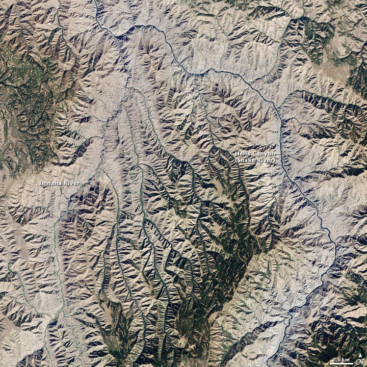
Bruce Sussman · Portland Weather

Portland Oregon Weather Blog | Emmy Award Winning TV News AMS Meteorologist

Connect with me!

  • Facebook
  • Instagram
  • LinkedIn
  • Twitter
  • YouTube
  • Home
  • Biography
  • Demo Videos
  • Wx Graphics
  • Community
  • School Visits
  • Weather Fun
  • Contact Bruce

Bruce Sussman, Meteorologist
Demo Reel | Weather Graphics
Resume & Experience

Subscribe to Blog Posts

Sign up to have the latest blog posts emailed directly to you!

Facebook Weather Page

Latest Tweets

Tweets by @forecastupdates

Portland Weather

Forecast Radar Cameras Photos
WeatherBug WeatherBug
Your weather just got better.

Categories

  • Climate Patterns
  • Earthquakes / Volcanoes
  • Extreme Weather
  • Heavy Rain / Flooding
  • Interviews
  • National Weather
  • Portland Weather
  • School Visits
  • Weather History
  • Weather Photos
  • Weather Research & Technology

Web Design & WordPress

Need help setting up a website?
Contact Kelli Sussman at
Consistent Image Web Design in Portland Oregon. She specializes in WordPress website design.

Exploring Our National Parks By Satellite

April 23, 2014 by Bruce Sussman 1 Comment

hells-canyon-image-photoRecognize this one?

It’s the deepest river canyon in the United States.

Nope. Not the Grand Canyon. Instead, it’s Hells Canyon along the Oregon – Idaho border. 

The top rim of Hell’s Canyon is exactly 8,043′ above the Snake River down below. That makes it a half mile deeper than the Grand Canyon! I only learned that because of a really cool slideshow that NASA’s Earth Observatory has put together for National Park Week, which is underway.

From Yosemite National Park’s green image to White Sands National Monument’s bright white to Joshua Tree National Park’s brown sand this is a cool satellite slide show of our national parks.

For some reason, they did not include the Grand Canyon or Yellowstone or Crater Lake in their slide show. So here’s a satellite image of the Grand Canyon and a satellite image of Yellowstone National Park and a satellite image of Crater Lake.

So even if you can’t head to these areas this summer…at least you can say you’ve been there…in a virtual reality sort of way!

Related posts:

  1. Say What? Another Satellite Is About To Crash To Earth
  2. If A NASA Satellite Doesn’t Fall Over Portland, Does It Still Make An Impact?
  3. Mississippi River Flood: Images From Space Show Area Around New Orleans
  4. Oklahoma Tornado: From The Air & From Space
  5. Spring Weather Outlook For Portland, Oregon, Washington And The Northwest

Filed Under: Weather Photos Tagged With: crater lake oregon satellite, deepest canyon in united states, grand canyon satellite, grand canyon vs. hells canyon, hells canyon elevation, hells canyon satellite, Joshua tree satellite image, national parks satellite, White Sands Satellite Image, Yellowstone satellite, Yosemite from space

Comments

  1. Douglas Kleps says

    April 24, 2014 at 3:30 pm

    Bruce what happen to you. The weather report will never be the same.The replacement gal is shrill and annoying. I miss you. Good luck

    Reply

Leave a Reply to Douglas Kleps Cancel reply

Your email address will not be published. Required fields are marked *

  • Facebook
  • Instagram
  • LinkedIn
  • Twitter
  • YouTube

Weather Links

  • Bruce Sussman Facebook
  • Bruce Sussman Twitter
  • National Weather Service
  • Consistent Image Web Design - Portland
  • New Moon Aesthetics
  • Pressure Washing Company Clackamas / Happy Valley
  • Recent Posts

    • What Is a Triple Dip La Niña?
    • Portland 2020 Weather ‘Year In Review’
    • How Long Will Portland Have World’s Worst Air Quality?
    • Save The Date — 27th Annual Winter Weather Forecast Conference
    • Earthquake Outlook For Western Oregon and SW Washington

    RETURN TO TOP
    © 2026 Bruce Sussman · Portland Weather · Contact Us · Site Map · Google+
    Consistent Image Web Design - Portland Oregon | WordPress Websites Portland